Finding data on the Dataset Catalogue
Finding data in SEED
Finding data in SEED
There are numerous ways to find data in SEED. You can search for:
- Any dataset in the dataset catalogue by scrolling through
- Use keyword searches, apply filters, use spatial search and advanced search
- Datasets on the SEED map. Refer to this section for more information on how to use the SEED map.
Listing all the data in the SEED Dataset Catalogue
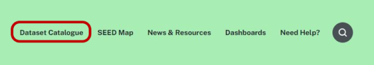
To see a listing of all the data in SEED, select the 'Dataset catalogue' link:
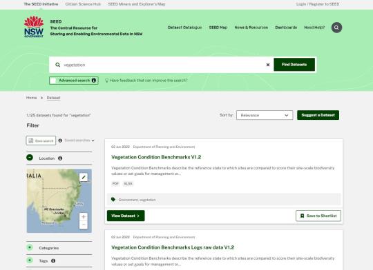
When you search for datasets in SEED (or select 'Dataset catalogue' on the SEED menu bar), any matching datasets are displayed on the Search Results page.
You can use the options on this page to:
- select a dataset to view details.
- refine the criteria to be more specific about the datasets you want to see.
- select one or more datasets to view on the map.
- change the order of results.
To find out more about a dataset
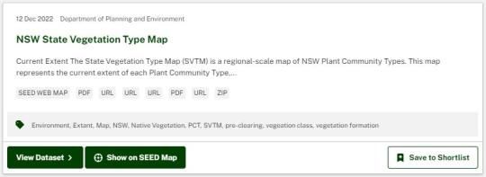
Each dataset is displayed with its title, summary description and formats of the applicable data and resource files. If it has a SEED map layer you will be able to click ‘Show on SEED Map’ to view the data on the map. For more information about a dataset, click its title:
Refining the criteria
Watch the video below for an overview of how to refine your search using filters, spatial search, and the search bar.
To use the search bar, you can type in keyword terms to get suggested datasets and tags that apply to your search. Don’t worry if you misspell a word, the search will return similar terms to help you refine your search.
If 'no results' are returned, it may be that:
- you are searching for a location. The search bar is for keyword (subject) searches only. (See below for location searches.)
- the type of data you are looking for is outside the current scope of SEED (environmental data), or
- the word(s) you are using are not included in the information that is searched by SEED (the dataset's title, description, category, tags and some metadata fields).
You can also use advanced search to refine your search further. For more information on how to use this, head to the advanced search page.
Filters
To apply filters simply expand the heading, search for a filter if applicable or draw a spatial location and click on it to apply to your search.
Available filters include:
- Location: spatial search for datasets that are located in an area of interest. For more information click here.
- Category: Select one or more environmental categories to see datasets that belong to that category.
- Organisation: The organisation that manages/created the dataset.
- Format: Use this if you want to view only those datasets that have resources in a particular format; for example, those that can be viewed on the SEED map.
- Tags: Keywords associated with the dataset.
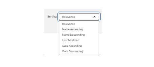
Changing the order of results
To change the display order of your search results, select an option from the 'Order by' dropdown list located at the top of the results:
- Relevance: Datasets that most closely match your search criteria.
- Name Ascending: In alphabetical order from A to Z
- Name Descending: In reverse alphabetical order.
- Last Modified: In order of the date the datasets were last modified
- Popular: Orders the datasets by their popularity.
Selecting datasets to view on the map
- To view a single dataset on the SEED map, click on the 'Show on SEED Map' button underneath the dataset description. Note: Not all datasets are able to be viewed on the SEED map.
- To view multiple datasets on the map, tick the 'Add to Selection' checkbox next to the required datasets (a maximum of 5 is recommended). Then in the message area at the top of the search results you can review and/or delete your selections. When you have finished making your selection, click the 'View on Map' button at the top of all the search results.
Note: There is no limit to the number of datasets that can be displayed at one time; however, more than five or so will make it difficult to see the data and slow the response rate of the map.
What data and resource formats are available?
The labels under each dataset provide a quick indication of the formats of the available data resources. These vary between datasets.
A summary of each is included here, but for a more detailed description see About datasets.
| SEED Web Map | Indicates the dataset can be viewed on the SEED Map. |
| Includes the Metadata Statement, Data Quality Statement, and any other written report that may be available in PDF format. | |
| XML | May include the Metadata Statement or other Resources available in XML web format |
| URL | Indicates a link to an external website containing additional information or resources. |
| XLS | Microsoft Excel file. |
| WMS, WMTS,WFS | Web Map Service, Web Map Tile Service, Web Feature Service. These are mediums for sending geospatial data across the Web |
| Esri Web Service | A GIS resource that is located on an ArcGIS Server site and is available to client apps. |
| SHP | (Shape file.) An ESRI vector data format for storing the location, shape and attributes of geographic features |
| MDB | A format used by Microsoft Access. |
For more information on resources and how to use them, go to the Dataset Software Resources page.